
August 18, 2026
The next release of Earth Volumetric Studio is focused on one theme: getting your models into GIS looking exactly the way they look in EVS. Rather than list features, let’s walk through a real workflow: building a clean, straightened 2D cross section of hydrocarbon data, then delivering the whole thing to ArcGIS Pro in a single click.
Building a Straightened Cross Section
Our example follows a transect through a hydrocarbon site. The new section profile support handles the whole 2D straightened cross-section workflow with four cooperating modules:
- section profile creates the straightened section itself along the transect
- section profile samples brings the borings, screens, and sample data into profile space
- section profile axes adds the distance and elevation grid, ticks, and labels
- section profile viewer displays it all in a dedicated 2D profile window
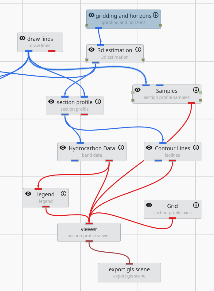
The application reads like the workflow: gridding and horizons feed 3d estimation, the drawn transect drives the section profile, and the profile’s data fans out to banded hydrocarbon data, contour lines, samples, and the grid, all meeting in the section profile viewer.
Two things make this dramatically nicer than profile workflows in earlier releases:
- Z scale is handled cleanly and quickly. Changing the vertical exaggeration updates the entire profile (data, samples, axes, labels) instantly, without rerunning any modules. Previously a Z scale change meant waiting for the whole application to reprocess.
- No more jitter. The section profile viewer renders the straightened section without the z-fighting and jitter artifacts that could appear when assembling profile views manually.
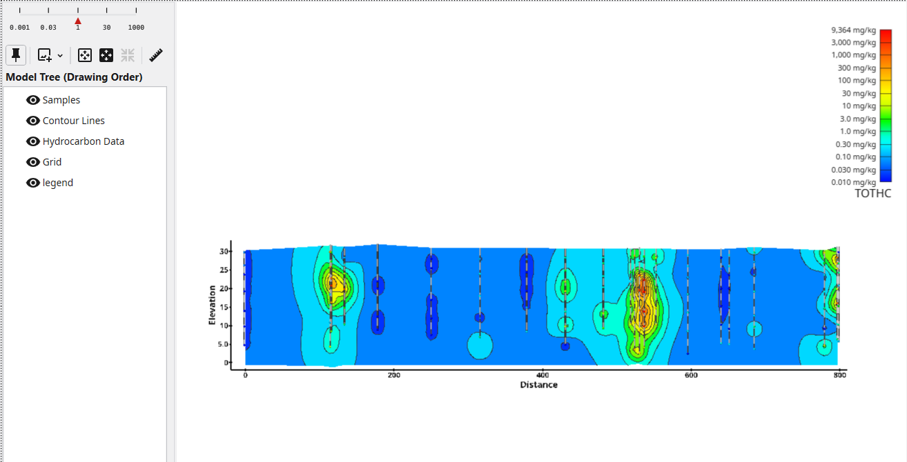
The result is a clean, presentation-ready section: log-banded TOTHC concentrations, contour lines, the borings that support them, and an analytic legend, all in true profile coordinates (distance along the transect versus elevation).
Delivering to ArcGIS Pro: One File, One Click
Here’s the payoff. The new export gis scene module, connected directly to the viewer (visible at the bottom of the application network above), writes the entire scene to a single ArcGIS Pro layer package with a single click.
Dragging that one file into ArcGIS Pro gives this:
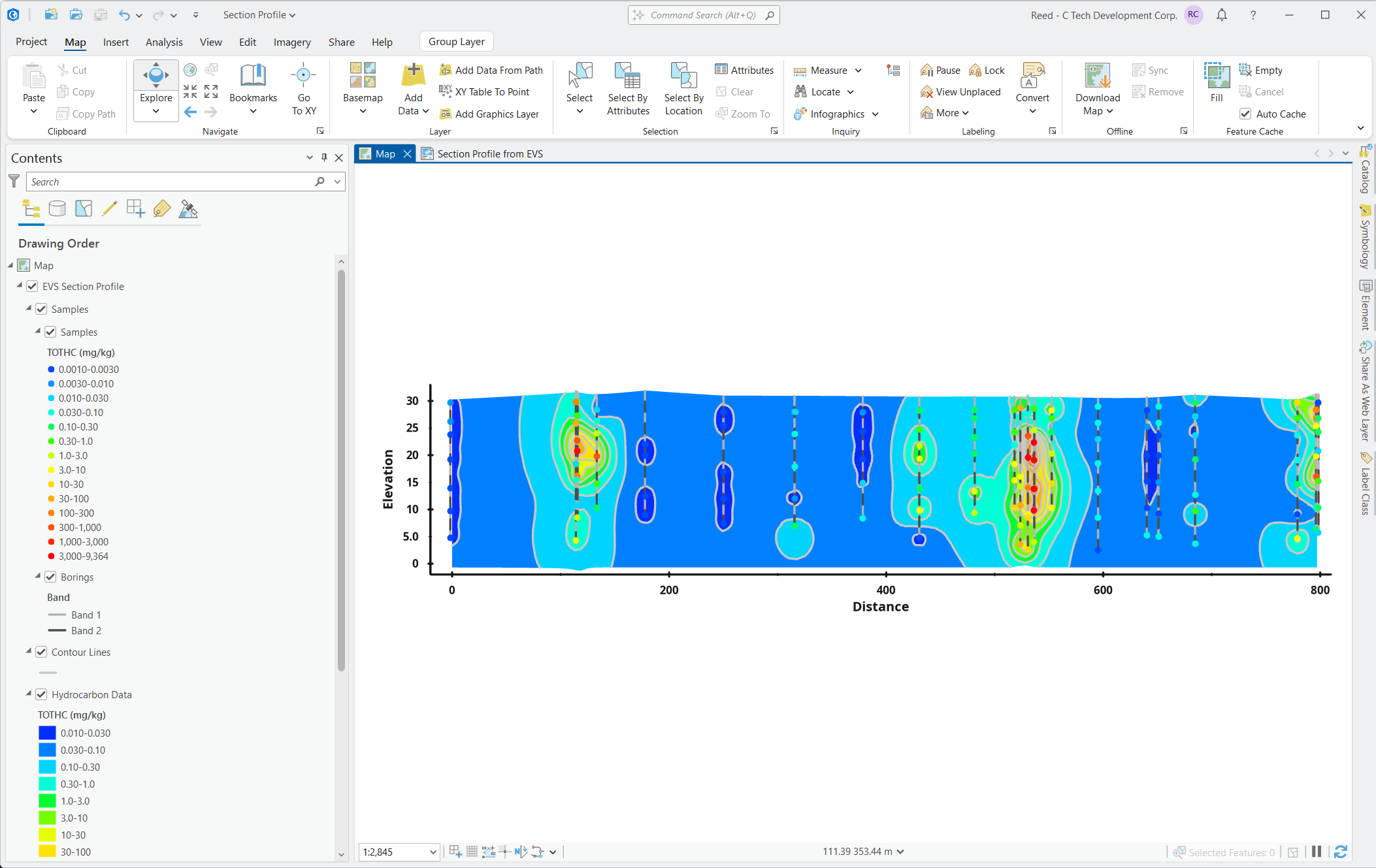
Look at the Contents pane. It mirrors the EVS scene: Samples with their log-banded TOTHC classes, Borings, Bands, Contour Lines, and the Hydrocarbon Data layer, each carrying the same colors, value ranges, and units (mg/kg) as the EVS legend. The log-decade class breaks (0.010 to 0.030, 0.030 to 0.10, and so on) are built the way the EVS legend builds them, not ArcGIS’s default uniform chunks. Nobody on the receiving end spends an afternoon rebuilding symbology.
Want to try it yourself? Download the actual layer package produced by this workflow and drag it into ArcGIS Pro:
Download the Layer Package (2.8 MB)Everything is queryable: the samples, borings, contours, and banded data are real features with attributes, not a flattened image. Click any sample point and ArcGIS Pro shows the full record:
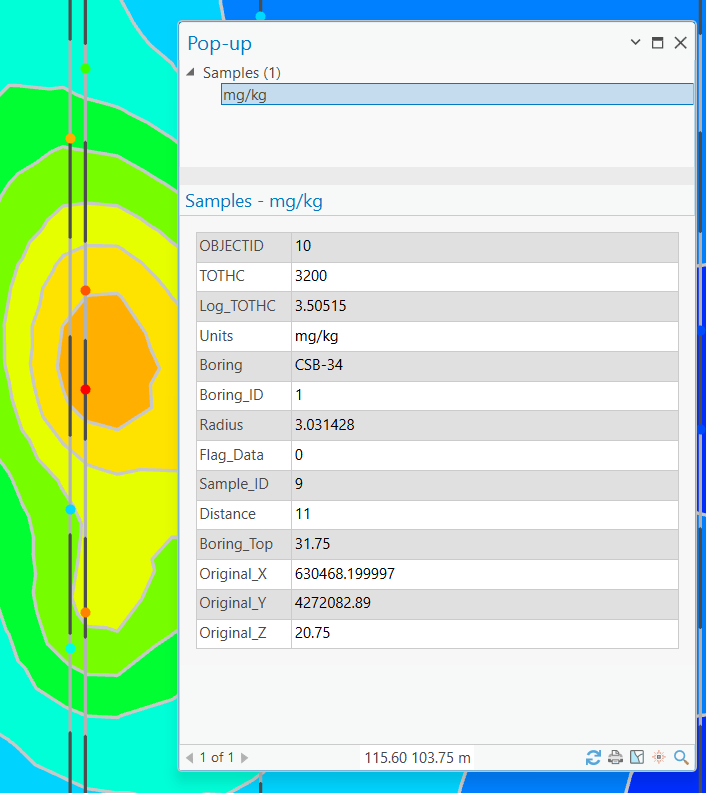
Boring names and full details pass through. This sample belongs to boring CSB-34, and the pop-up carries the measured TOTHC value, its log-processed value, units, the sample and boring IDs, the distance along the transect, the boring top elevation, and the original site X/Y/Z coordinates. The cross section itself exports with full data as well, including geologic material names as readable text columns. Your GIS recipients can identify, query, and select against the same information you see in EVS.
And because the profile was exported in XY plan orientation (distance along the transect versus elevation), it works naturally in a 2D map.
And Everywhere ArcGIS Pro Goes Next
Because the export produces native ArcGIS Pro layers, it is immediately compatible with everything ArcGIS Pro can publish, with no extra preparation:
Publish to ArcGIS Online. The same section profile, shared as a web map anyone in your organization (or the public) can open in a browser. See it live:
View the Web Map on ArcGIS OnlineExport to PDF with vectors. ArcGIS Pro’s PDF export preserves the layer structure, so the delivered document is not a flat image: recipients in Adobe Acrobat get a Layers panel mirroring the scene (grid labels, samples, contour lines, hydrocarbon data) and can toggle each on and off.
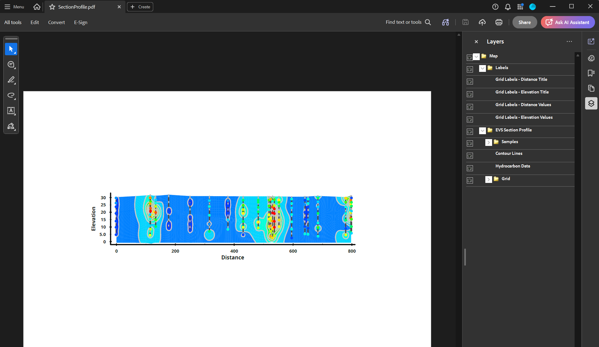
One EVS application, one export module: an interactive ArcGIS Pro package, a browser-based web map, and a layered vector PDF, all carrying the same styled, queryable data.
Everything Else Coming for GIS
The full release goes well beyond this workflow. In brief:
- Scene export: the new export gis scene module writes every visible object (points, lines, surfaces, volumes, labels) to one ArcGIS Pro layer package with EVS styling (#317)
- Purpose-built exports: the axes, section profile axes, and section profile samples modules each export a single styled .lpkx (#305, #306, #316)
- Voxel layers for volumes: the volume renderer exports its voxel grid to netCDF for ArcGIS Pro voxel layers, with the EVS view as a live preview: same grid resolution, same data, log values for color stretching plus real values for probing, nodal (chemistry) and cell (material) data both supported (#301); a styled .lyrx ships alongside so the voxel layer loads looking like EVS, including one class per geologic material (#318)
- EVS-quality legends: target break counts, log-decade banding, value ranges, and units in ArcGIS legends (#319)
- New vector formats: GeoPackage, File Geodatabase, GML, FlatGeobuf, and SQLite/Spatialite on import and export, with multi-layer support and safer write modes (#254, #320)
- New plan viewer: a locked top-down map view with georeferenced image export (#295)
- Consistent coordinate systems: one EPSG/WKT control across every GIS exporter, with automatic protection against tagging origin-relative data (#321)
These features are in internal testing now and will arrive in an upcoming EVS release. If your deliverables end up in ArcGIS Pro, this release is built for you.